China tolerated foreign traders coming in by sea. Most of these were Arab and Indian, but this trade was not essential for China. Nor was trade via the land route; the “Silk Road” that reached as far as the Middle East, as well as India and all points along the way. Since China preferred to be paid in silver, this limited how much distant customers could afford. That worked well for China. Let the foreigners come to China with their offerings and, as long as they recognized Chinese supremacy, they would be tolerated. "With the Silk road firmly under Mongol control, trade was able to dramatically increase between the East and the West. Mongols actually increased accessibility of trade routes, by building roads. They originally built these roads to serve as communication routes across their vast empire. But they also had the effect of making the terrain more traversal for merchants and other travellers. Genghis Khan recognized that in addition to the economic boom that trade brings, it also makes parties reliant on one another. He hoped that this inter-dependency would lead to greater loyalty among his subjects. The issue with the increase in trade between the East and the West was an increase in the spread of disease. As more and more people travelled between China and Europe, a series of deadly disease were exchanged. The most noteworthy of these diseases was the Black Plague, which is said to have been brought to the Byzantine Empire by the Mongols. The Black Plague would go on to kill about 50% of the population of Europe." Gunpowder & Cannons: Russian, french, british modern artillery systems are improvements from 18th century's coastal heavy cannons used for defence or naval demi-cannons used for close-combat (hundred carried on each multi-deck ship), starting with "Prince Rupert of the Rhine" during the Anglo-Dutch wars (1652 – 1784). According to the Regulation by Coll Borgard in the year 1716, the Armstrong Pattern Gun system came into use to replace the ancient smooth-bore artillery. John Browne was a British merchant who had developed a type of light cannon known as "The Drake" in the 1620s, which enabled ships to carry more cannons. He was King's Gunfounder in 1615 and he patented and had a monolopy (with the King being a partner) on the casting of pots, pans and firebacks, made in his own furnaces and six other furnaces. In India, the outbreak of the Seven Years War in Europe renewed the long running conflict between the French and the British trading companies for influence on the subcontinent. The French allied themselves with the Mughal Empire to resist British expansion. The war began in Southern India but spread into Bengal, where British forces under Robert Clive recaptured Calcutta from the Nawab Siraj ud-Daulah, a French ally, and ousted him from his throne at the Battle of Plassey in 1757. In the same year, the British also captured Chandernagar, the French settlement in Bengal. The French capital in India, Pondicherry, fell to the British in 1761; together with the fall of the lesser French settlements of Karikal and Mahé this effectively eliminated French power in India. The success of the Armstrong-Frederick Pattern Guns of 1760 with the Royal Navy, may be attributed to two factors. The first was the reduction of service gunpowder charge from ½ the shot weight to ⅓. The second was the change in British gun-founding technique from casting hollow barrel guns and reaming them out to size, to casting solid barrels and drilling out the bore. This newer technique produced far fewer flaws in the casting resulting in stronger barrels. Thomas Blomefield became "Inspector of Artillery", in 1780. In 1787 cast iron guns of Blomefield's own design were made. He made three significant alterations to the Armstrong design. Firstly, the breech was made more rounded, eliminating the prominent mouldings. Secondly, the first reinforce was made almost cylindrical, the second reinforce was strongly tapered and the chase strengthened. Thirdly, a ring was added to the cascable which allowed free movement of the breech ropes, used to restrict the gun's recoil aboard ship. This free movement allowed the gun to be trained at an angle to the side of the ship and still have effective recoil restraint. The radical carronade was largely developed by private enterprise toward the end of the 1770s, when naval tactics were changing from rigid "line of battle" actions to more close quarters combat. They were used during the American War of Independence. The idea of the carronade was not new, in the early 1600s short barrelled guns in service were referred to as "cutts". The carronade saw wide use during the Napoleonic wars to great effect. These were initially made by cutting off the muzzle of a failed gun, but later they became a type of their own. The Finnish company Tampella developed 130mm B7 Pattern Guns 1913. Finnish 152mm 152-H-37 is the Soviet M-1937 ML-20. Soviet 152mm M1938 (M-10) heavy howitzer, was developed based on pre-WW-1 152mm M1910 siege gun designed by Schneider, when Soviets could not built heavy German 152mm and 122mm howitzers (Soviet had to use M1931 A-19 gun on M1937 ML-20 carriage). In 1960 Tampella began developing the 122 mm 122-K-(60) concept for a new gun. 155mm GCT (meaning, high rate of fire) cannon was developed in 1969 by the Giat Ind. (now Nexter) to replace the 105mm gun on the modified AMX-13 self-propelled light tank (sacrificing protection). 155mm L-33 Ro'em by Soltam is a late 1960s self-propelled howitzer on the chassis of the WW-2 era American M4A3E8 Sherman tank to be used in Yom Kippur war (1973). 155mm L33 Model-77 "Argentine Model" gun was developed by CITER in 1970s to replace WW-2 era M114-A1 and were used in Falklands War (1982). Soviets developed the excellent 130mm 130K (54) or M-46 during the cold war. The Finnish finally modified the 122 mm 122-K-(60) concept to the 130mm 130-K-(90-60) towed coastal guns (which was developed by Tampella in the 1980s), and these were manufactured by Vammas. The gun carriage design was used for Tampella's heavy 155 mm M-83 (called K-83 in the army), as well as for the Israeli Soltam M-68 light gun. 152mm L-32 were developed from Soviet M1938 (M-10) howitzer which were captured by Nazi army and by Finland. 120 different modified models were made to develop 152mm 152-H-88. Soviets developed 2A36 Giatsint-B to replace 130mm 130K (54) or M-46, the 2A36 Giatsint-B self-propelled version was called 2S5. U.S had been fielding M110 and M115 self-propelled howitzer in South korea. South korean Kia precision Machine Tool Co. (today the WIA Corp.) in 1984 developed 105mm KH-178 and air-transportable 155mm KH-179 towed field guns, derived from the excellent British 105-mm light gun and the Rheinmetall experimental version of the M101 (Kia also licence built M101) and incorporated the better points of each into its KH-178. Both systems are installed in the cylinder yoke end which supports and enables the barrel to slide horizontally during recoil and counter-recoil. GC-45 (Gun Canada 45 cal) was developed by Project HARP's ballistics expert Dr. Gerard Bull. Israel bought GC-5 gun from South Africa & renamed it to Athos gun (Atmos system). Austria also bought GC-5 but sold the technology to China, who has made 155mm PLL01 (& PLZ-05). French Nexter and Bofors of Sweden has developed 155mm Trajan while South koreans developed the excellent 155mm K9 which is being used by many countries, including Finland. 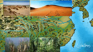 The Han people did not originally live as far south as Guangdong (Canton) or as far southwest as Sichuan, nor in the far northern areas. There are some genetic differences between the Northern Han and Southern Han (including Cantonese) that persist to the present day. Chinese civilization and pre-history starts with the tiny Xia dynasty, which left very few records. The most archaic written history and bureaucratic system of China began during the Bronze Age in China around Yellow River valley (Tang dynasty in 1600 BC), but traditionally Chinese imperial culture starts from the Zhou dynasty (1046 BC). China's first dynasty began with the Han dynasty, when Buddhism arrived and the Silk road trading began with Europe and Asia. In 202 BC. This is when Confucius began. Although Tang Dynasty (China's golden period) was one of the most prosperous for China, it was the Song (Sung) Dynasty that became the most technological and scientifically advanced nation in the world. Song played a major role in creating iconic China, and many of the world’s greatest inventions were brought about by the great innovators of this dynasty. The first important battle between the Mongol Empire and the Jin dynasty was the Battle of the Badger Mouth, a mountain pass in Zhangjiakou, which took place in 1211. While Genghis headed southward, his general travelled even further east into Manchuria and captured Mukden (Shenyang). The Khitan leader Liu-ke had declared his allegiance to Genghis in 1212 and freed Manchuria from the Jurchen Jin dynasty. Battle of Wusha Fortress: The Jurchen Jin dynasty's chancellor, Duji Sizhong led the bulk of the Jurchen Jin dynasty's imperial army to the northwestern frontline but could not match the numbers of Mongol horsemen. The chancellor sent troops to reinforce the defences along the Jurchen Jin dynasty's Great Wall and prevent the Mongols from advancing. Genghis Khan himself led the main Mongol army to attack Wusha Fortress to destroy the Jurchen Jin dynasty's imperial army's defence lines. He also ordered his third son to lead a separate force to attack the Jin western capital, Xijing; to block enemy reinforcements. Duji Sizhong was killed in action by the end of June 1211. Battle of Wild Fox Ridge / Yehuling in 1211: Wanyan Chengyu succeeded as Jurchen Jin dynasty's chancellor, was put in charge of the Jurchen Jin dynasty's imperial army. His aim was to make use of the mountainous terrain in Yehuling to obstruct the Mongol cavalry. However, the difficult terrain and wide distances also made communication and coordination of Jurchen Jin's troops difficult. Although the Jurchen Jin's imperial army outnumbered the invading Mongol forces nearly ten times its own, Wanyan Chenyu ordered them to be spread out throughout the Wall in an attempt to block the Mongol approach, meaning in any one place, several sections and ramparts of the wall have only a few defenders on them. The Wall itself is not a continuous defensive wall but a system of fortifications with many walls not connected towards each other but are supported and reinforced by castles and fortresses. This is a fact that Genghis Khan recognized, having his scouts keep watch on much of the Wall before he could engage his forces. He also managed to induce Jurchen Jin's imperial court official to defect to his side. Having gained intelligence from his scouts, he thus recognized that the least defended portion of the Wall's defensive system was at the Wusha Fortress, which leads to a desert ridge called Yehuling, inhabited by wild foxes hence the name of the area which in Chinese literally means the "Wild Fox Ridge". Wanyan Chengyu managed to rally the scattered forces. The Mongols swiftly surrounded the Jurchen Jin dynasty's forces and executed a focused and concentrated attack, engaging them in fierce battle for three days. Eventually, Jurchen Jin imperial army's field commander was killed, and the army became disorganized, lost its morale, and started to break. The entire Jin army was destroyed, while Wanyan Chengyu barely escaped alive. Wanyan Chengyu was replaced by Tushan Yi as chancellor. In 1212 to 1215, under Mongol pressure, Emperor Xuanzong of the Jurchen Jin dynasty relocated the capital (and their forces) from Beijing to to Bianjing (present-day Kaifeng, Henan) in the south. Zhongdu fell to the Mongols in 1215. While the Jurchen Jin dynasty managed to retain power for the next two decades or so, its core was severely weakened. In spite of being defeated by Mongols, Shuhu Gaoqi, when he was in control of the imperial court in 1217, foolishly decided to invade the Southern Song dynesty for the first time in nearly 30 years, instead of defending its borders from the Mongols. This war lasted until 1224 and was a total failure. Jurchen Jin dynasty's imperial armies under Emperor Aizong (Wanyan Shouxu) successfully stopped several Mongol offensives, with major victories in the process, such as at the Battle of Dachangyuan in 1229, Battle of Weizhou (1230), Battle of Daohuigu (1231). In 1224, the Emperor Aizong (Wanyan Shouxu) declared that the Jurchen Jin dynasty would never again invade the Song dynesty. But the damage had already been done. The Mongols had systematically rooted out all resistance in Shanxi, Hebei and Shangdong from 1217–23. The next greatest war waged by the Mongols was against the Khwarazmian Empire, an Empire in the modern-day area of Turkmenistan, Iran, and Afghanistan. When the Shah of the empire refused to give the governor to the Mongols, the Mongols responded with an invasion of 100,000 men. The war lasted from 1219-1221, and is largely considered a one-sided affair, in which the Mongols besieged and slaughter city after city (killing the entire population of cities that did not immediately surrender to them). When Genghis Khan invaded Punjab in pursuit of Jalal-ad-Din, the Mamluk sultan Iltutmish was careful not to provoke Genghis Khan by refusing to give Jalal-ad-Din asylum in India. Upon conclusion of the war, Genghis was forced to return East to deal with the revolting Xi Xia kingdom, which had allied with the remains of the Jin Empire. In 1223, during a long siege in Chang'an (located in Shaanxi), the Mongols had to retreat when their general Muqali died of illness, and in which the Xi Xia reinforcements troops supporting the Mongols gave up and went home, incurring the wrath of Genghis Khan. The Xi Xia were forced to surrendered in 1227 after their capital was taken. Genghis Khan died shortly after on August 18, 1227. In 1233, Emperor Aizong (Wanyan Shouxu) had abandoned Kaifeng and dispatched diplomats to implore the Song dynasty for supplies as he gathered his army. Pucha Guannu then launched a coup and made the Emperor Aizong (Wanyan Shouxu) his puppet. Pucha Guannu achieved a remarkable victory against the Mongols. However, courtiers urged the emperor to move to Caizhou, which had stronger walls and more provisions and troops. Emperor Aizong (Wanyan Shouxu) used a plot to assassinate Guannu, and then quickly began preparations to move to Caizhou. New reports reached the Emperor Aizong (Wanyan Shouxu) that Caizhou was too weak in defences, troops and supplies. Wanyan Heda was a great general of Jurchen Jin dynasty. Mongol commander was dispatched to attempt a frontal attack in Tong Pass, but Wanyan Heda defeated him and forced them to withdraw in 1230. In 1231, the Mongols attacked again and finally took Fengxiang. Jurchen Jin troops in Chang'an (located in Shaanxi) panicked and abandoned the city, pulling back to Bianjing (present-day Kaifeng, Henan). Wanyan Heda learned of Mongol plans to use a three-pronged attack to converge on Kaifeng from north, east and west. At Dengzhou, Wanyan Heda set an ambush in a valley with numerous cavalry hidden behind the crest of either mountain, but spies alerted the Mongols, and they kept their main force with the supply, sending only a smaller force of light cavalry to skirt around the valley and attack the Jin troops from behind. Wanyan Heda saw that his plan had been foiled and prepared his troops for a Mongol assault. At Mount Yu, the two armies met in a pitched battle. The Jurchen Jin dynasty's imperial army had an advantage in numbers, and fought fiercely. The Mongols then withdrew from Mount Yu. After the battle at Mount Yu, Mongols adopted a strategy of exhausting the enemy. The Jin troops had little rest all the way from Dengzhou, and had not eaten for three days because of the severing of their supply lines. Their morale was plummeting, and their commanders were losing confidence. When they reached Sanfengshan (Three-peaked Hill), a snowstorm suddenly broke out, and it was so cold that the faces of the Jin troops went as white as corpses, and they could hardly march. Rather than attack them when they were desperate with their backs to the wall, the Mongols left them an escape route and then ambushed them when they let down their guard during the retreat. The Jin army collapsed without a fight, and the Mongols pursued the fleeing Jin troops relentlessly. The Mongols easily took 10 cities, and burnt all the supplies they captured so as to cut off Wanyan Heda's supply lines. The Mongols spared cities from massacre and sacking if they surrendered, such as Kaifeng. Han Chinese and Khitan soldiers defected en masse to Genghis Khan against the Jurchen Jin dynasty. Jurchen Jin dynasty envoys reported to the Song dynasty that the Mongols would invade the Song dynasty after they were done with the Jurchen Jin—a forecast that would later be proven true—but the Song dynasty ignored the warning and rebuffed the request. They instead formed an alliance with the Mongols against the Jin. The Song dynasty instead provided supplies to the Mongols in return for parts of Henan. Kublai Khan was the grandson of Genghis/Chinggis Khan and the founder of the Yuan Dynasty in 13th-century China. He became the first foreign ruler of China after his skilled long-range archers on horses were used to defeat the armies of Song dynasty. (General Shi Tianze defected to the Mongol Empire's forces upon their invasion of the Jurchen Jin dynasty. Later, he was promoted to the post of deputy prime minister and became the first Han minister of the Yuan dynasty.) His death in 1294 weakened the Mongols and a rebel army overthrew them. The Ming dynasty with the help of jurchen feudal tribes (later known as manchu) pushed the Mongols out of China and started a strong navy. In the 17th century Tibetan Buddisim became popular. Despite the growing intimacy of Manchu-Mongol marriage ties, the last Mongolian Khan of Northern Yuan dynasty, Ligdan Khutugtu Khan was defeated in battle in 1632 by Hong Taiji (Eighth son of a Ming guard named Nurhaci). 'Hong' is written as 'Hung' in manchu (originally manchu were known as jurchen feudal tribe of manchuria steppe) and 'Huang' in in chinese. His name is borrowed from a well-known mongolian title Khong Tayiji (meaning Crown Prince). He is sometimes mistakenly called Abahai, in Western literature due to poor Russian translation of the honorary name given to young prince. He later changed his name whe he founded the Qing dynasty and took the title of the Great Khan. Unlike his father, he started using the majority Chinese Han officials and Confucious beliefs. The Manchu leaders themselves, like Hung Taiji, did not personally believe in Tibetan Buddhism and did not want to convert, in fact the words "incorrigibles" and liars" were used to describe the Tibetian Lamas by Hung Taiji, however he patronized Buddhism in order to exploit and control the Tibetans, Koreans and Mongolians. He did not live to see the Qing dynasty (1644-1911) that was the largest and last imperial dynesty of China (but they were defeated in Burma and VietNam). With the farming of American food crops like maize and potato there was a huge population growth. The Qing empire became isolationist had failed to expand their naval power. The empire lasted for almost 300 years until the last opium war with Britain amphibious forces (weakened by opium addition and Sino-Japanese wars over Taiwan & Korea). Since 1921, Mongolia itself had become essentially a client state of the Soviet Union. The East Turkistan Republic was the primary product of an independence movement led by Uyghur and other Turkic people living in East Turkistan, and multi-ethnic and Turkic in character, including Kazakhs, Kyrgyz Uzbeks, Tatars, and Mongols. Following the assassination of its leaders in a tragic "plane crash" in August 1949, along with an invasion by the then newly established China, the East Turkistan Republic was overthrown on December 22, 1949. Uyghurs had always been caught between China and the Soviet Union. The region formed part of the Great Game. In accordance with the Yalta Agreement, Soviet-Chinese negotiations started in June 1945 and ended in August after the Chinese Nationalist government guaranteed Russian interests in Mongolia and Manchuria. In these negotiations, Chinese Nationalist leader Chiang Kai-shek demanded from Stalin that Moscow not support East Turkestan independence. Stalin suggested to Mao’s representative Liu Shaoqi that Mao establish the PRC before the end of 1949 and enter Xinjiang province as soon as possible. In February, 1950, Mao and Stalin signed an agreement of Sino-Soviet friendship in Moscow, and Mao agreed to establish a company that would allow the Soviet Union to extract petroleum, uranium and other resources from Xinjiang province. 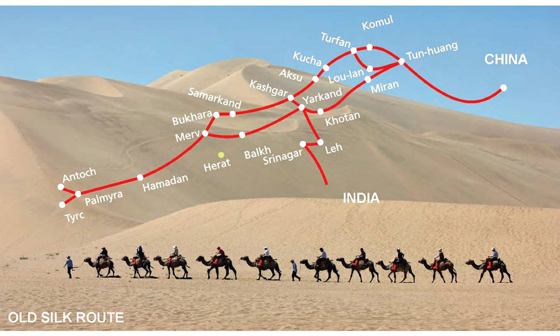 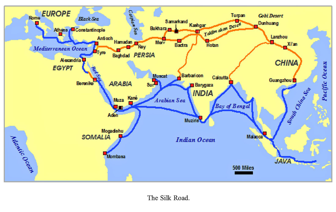 The ancient peoples of the Sahara imported domesticated animals from Asia between 6000 BC and 4000 BC. Foreign artifacts dating to the 5th millennium BC in the Badarian culture of Egypt indicate contact with distant Syria. In predynastic Egypt, by the 4th millennium BC shipping was well established, and the donkey and possibly the dromedary had been domesticated.Domestication of the Bactrian camel and use of the horse for transport then followed. By the second half of the 4th millennium BC, the gemstone lapis lazuli was being traded from its only known source in the ancient world - Badakshan, in what is now northeastern Afghanistan - as far as Mesopotamia and Egypt. By the 3rd millennium BC, the lapis lazuli trade was extended to Harappa and Mohenjo-daro in the Indus Valley Civilization of modern day Pakistan and northwestern India. The Indus Valley was also known as Meluhha, the earliest maritime trading partner of the Sumerians and Akkadians in Mesopotamia. Routes along the Persian Royal Road, constructed in the 5th century BC by Darius I of Persia, may have been in use as early as 3500 BC. Historically, the Indian Ocean was a major trade route, with Chinese and Arab trade predominating, moving silk from China, spices from Indonesia to India’s Malabar Coast and Arab trade in slaves, ivory and sandalwood and ebony which made the East African Swahili Coast (from Kenya to Mozambique) fabulously wealthy. The Silk Route is a series of trade and cultural transmission routes that were central to cultural interaction through regions of the Asian continent connecting East and West by linking traders, merchants, pilgrims, monks, soldiers, nomads and urban dwellers from China to the Mediterranean Sea during various periods of time. The first person who used the term "Seidenstraße" or "Silk Road" was the German geographer Ferdinand von Richthofen in 1877. Geographically, the Silk Road is an interconnected series of ancient trade routes between Chang'an (today's Xi'an) in China, with Asia Minor and the subcontinent, and Rome, and helped to lay the foundations for the modern world. The Silk Route extends westwards from the commercial centres of North China, the continental Silk Road divides into north and south routes to avoid the Tibetan Plateau. The northern route travels northwest through the Chinese province of Gansu, and splits into three further routes, two of them passing north and south of the Taklamakan Desert (through modern day Kyrgyzstan and Xinjiang) to rejoin at Kashgar; and the other going north of the Tien Shan mountains through Turfan and Almaty (in what is now southeast Kazakhstan). All routes join up at Kokand in the Fergana Valley, and the roads continue west across the Karakum Desert towards Merv, joining the northern route briefly. One of these routes turns northwest along the Amu Darya (river) including Bukhara and Samarkand the center of Silk Road trade to the Aral Sea, through ancient civilizations under the present site of Astrakhan, and on to the Crimean peninsula.From there it crosses the Black Sea, Marmara Sea and the Balkans to Venice, another crosses the Caspian Sea and across the Caucasus to the Black Sea in Georgia, thence to Constantinople. The southern route is mainly a single route running through northern India, then the Turkestan-Khorasan region into Mesopotamia and Anatolia; having southward spurs enabling the journey to be completed by sea from various points.It runs south through the Sichuan Basin in China and crosses the high mountains into northeast India, probably via the Ancient tea route.It then travels west along the Brahmaputra and Ganges river plains, possibly joining the Grand Trunk Road west of Varanasi. Through northern Pakistan and over the Hindu Kush mountains to rejoin the northern route briefly near Merv. It then followed a nearly straight line west through mountainous northern Iran and the northern tip of the Syrian Desert to the Levant. From there Mediterranean trading ships plied regular routes to Italy, and land routes went either north through Anatolia or south to North Africa. Another branching road traveled from Herat through Susa to Charax Spasinu at the head of the Persian Gulf and across to Petra and Alexandria from where ships carried the cargoes to Rome and other Mediterranean ports. Macedonian cuisine (Makedonska kujna) is the traditional cuisine of the Republic of Macedonia—a representative of the cuisine of the Balkans—reflecting Mediterranean (Greek and Turkish) and Middle Eastern influences, and to a lesser extent Italian, German and Eastern European (especially Hungarian) ones. The relatively warm climate in the Republic of Macedonian provides excellent growth conditions for a variety of vegetables, herbs and fruits. Thus, Macedonian cuisine is particularly diverse. Famous for its rich Shopska salad, an appetizer and side dish which accompanies almost every meal, Macedonian cuisine is also noted for the diversity and quality of its dairy products, wines, and local alcoholic beverages, such as rakija. Tavče-gravče and mastika are considered the national dish and drink of the Republic of Macedonia, respectively. In antiquity, most of the territory that is now the Republic of Macedonia was included in the kingdom of Paeonia, which was populated by the Paeonians, a people of Thracian origins, but also parts of ancient Illyria and Dardania, inhabited by various Illyrian peoples, and Lyncestis and Pelagonia populated by Molossian tribes. None of these had fixed boundaries; they were sometimes subject to the Kings of Macedon, and sometimes broke away. In 336 BC Philip II of Macedon conquered Upper Macedonia, including its northern part and southern Paeonia, which both now lie within the Republic of Macedonia. Philip's son Alexander the Great conquered the remainder of the region, reaching as far north as the Danube, and incorporated it in his empire. The Romans included most of the Republic in their Province of Macedonia, but the northernmost parts lay in Moesia; by the time of Diocletian, they had been subdivided, and the Republic was split between Macedonia Salutaris and Moesia prima. In 280 BC the Gallic invaders under Brennus ravaged the land of the Paionians, who were further hard pressed by the Dardani. Later Paeonia consolidated again, but in 217 BC the Macedonian king Philip V of Macedon (220-179 BC), among other things succeeded in uniting most from the separated regions of Dassaretia and Paionia into the Macedonian kingdom. In 146 BC, the Roman legions led from the Roman general Quintus Caecilius Metellus defeated Andriscus of Macedon in 148 BC. Paionia around the Axios formed the second and third districts respectively of the Roman province of Macedonia (Livy xiv. 29). Centuries later under Diocletian, Paionia and Pelagonia formed a province called Macedonia Salutaris, belonging to the Praetorian prefecture of Illyricum, but the northern border regions, inhabited by the Dardani, became a part of Moesia Superior. By AD 400, however, the Paionians had lost their identity, and Paeonia was merely a geographic term. From the fifth century BC to the first century BC, Zoroastrianism spread into the Western Regions of China. It was regarded as the earliest religion passing to this area. It was once the state religion of Persia. After the rise of Arab Empire, Zoroastrianism was forced to move to the east. The religion developed rapidly during the Southern and Northern Dynasties (420-589) and the Tang Dynasty (618 - 907). After the Song Dynasty (960-1279), this religion had largely disappeared although its practices were carried on by the Uygurs (Uigurs) and the Tajiks. Manicheism is a mixture of Zoroastrianism, Judaism, Christianity and ancient Greek ideas. In contrast to Zoroastrianism, it was very popular among the common Chinese people. Though it was prohibited by the Tang Dynasty, it had a great influence on people. Nestorianism, a school of Syrian Christianity, has many dogmatas and doctrines different from traditional Christianity. In 635, it was introduced into China via the time-honored Silk Road. Tang Emperor Taizong, Li Shimin ordered people to build a temple to practise Nestorianism. The temple was variously called Persian Temple, Roman Temple and Daqin Temple. From the seventh century AD, Arab muslims traveled to China by the Silk Road or the sea route to spread Islam. In the Tang Dynasty, Guangdong Province and Quanzhou were the strongholds of most Islamic believers. Islam had a profound effect on spiritual beliefs in China. 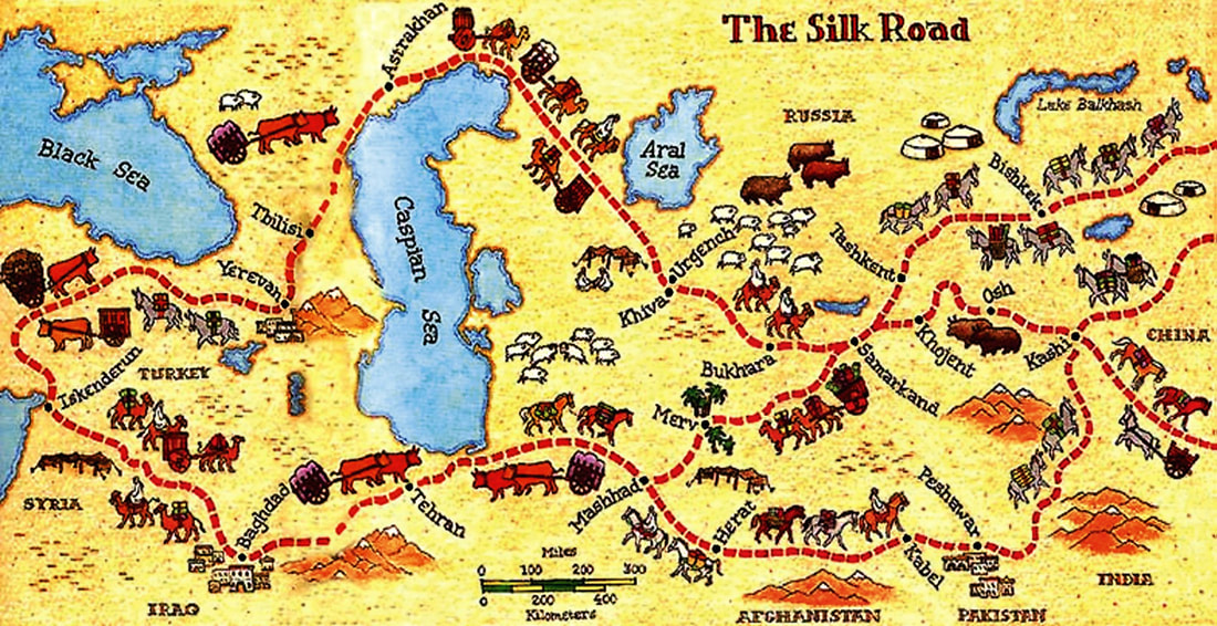 Roman rule Temple of Bacchus in Latakia Latakia Tetraporticus, built by Septimius Severus in 183 In 64 BCE, the Roman legate Pompey formally abolished the Seleucid Empire, and created the new Roman province of Syria. During the struggle for power between Augustus Caesar and Marcus Antonius, the latter managed to win temporary support from Laodicea during his brief governorship of Syria through the remission of certain taxes and the promise of autonomy. Following the defeat of Marcus Antonius, the Romans modified Laodicea's name, changing it to Laodicea-ad-Mare and the city flourished again as an entrepôt for East-West trade, second only to Antioch. This commerce was systemized with the construction of the Via Maris, a coastal road that ran south from Antioch to Damascus and Beirut via Laodicea.In the first century BCE, Herod the Great, king of Judaea, furnished the city with an aqueduct, the remains of which stand to the east of the town. Initially the Romans deployed four legions in Syria, one of which, the Legio VI Ferrata, was likely based in Laodicea. In AD 193, the city was sacked by the governor of Syria, Pescennius Niger in his revolt against the new emperor Septimius Severus. In 194, Septimius Severus reorganized Syria into five new provinces. One of these Coele-Syria, including all of northern Syria, briefly had its capital in Laodicea before reverting to Antioch. Septimius Severus considered Antioch to be more degenerate than Laodicea, and sought to punish Antioch for having supported the aspirations of his rival Pescennius Niger. Septimius Severus endowed Laodicea with four colonnaded streets which divided the city into a series of rectangles. Roman Laodicea, based on the foundations of the Seleucid grid, was laid out along a vertical axis stretching for 1.5-2 kilometers from north to south, linking the center of the town with the northern road to Antioch, and forming the cardus maximus (main commercial street). The east-west axis consisted of three main streets: the first linked the port to the citadel, the second linked the port to the Apamea road, and the third linked the port to a monumental four-way arch, or tetrapyle, which was erected at the point of intersection with the north-south colonnaded avenue. Septimius also built baths, a theatre, a hippodrome, numerous sanctuaries and other public buildings in the city. Rome regarded Laodicea as a key strategic seaport in the prized province of Syria. Throughout the third and fourth centuries Laodicea remained dependent on Antioch. In 272, the city was seized by Zenobia, the queen of the Palmyrene Empire, following her abortive attempt to take Antioch from Emperor Aurelian. After the revolt of Antioch in 378, Laodicea returned to imperial favor and enjoyed prosperity under the Byzantine Empire, established in Constantinople following the split of the Roman Empire late in the fourth century. In 494, the town was damaged by the first of a long series of earthquakes. In 528, Emperor Justinian I created the new province of Theodorias out of the coastal belt around Laodicea, which was rebuilt and fortified against the increasing Persian threat. In 555, another earthquake devastated Latakia. A sizable Jewish population lived in Laodicea during the first century. The heretic Apollinarius was bishop of Laodicea in the 4th century. The city minted coins from an early date. Ancient settlement and founding The location of Latakia, the Ras Ziyarah peninsula, has a long history of occupation. The Phoenician city of Ramitha was located here, known to the Greeks as Leukê Aktê 'white coast'. Ramitha dates at least to the second millennium BCE and was a part of the kingdom of Ugarit a few miles further north. As Ugarit declined at the end of the second millennium BCE, the better natural harbor facilities at Ramitha increased its importance. The settlement became part of the Assyrian Empire, later falling to the Persians, who incorporated it into their fifth satrapy, Abar-Nahara, beyond the river. It was taken by Alexander the Great in 333 BCE following his victory at Battle of Issus over the Persian army led by Darius III, beginning the era of Hellenism in Syria. After the death of Alexander the Great in 323 BCE, Northern Syria fell under the control of Seleucus I Nicator. He founded the city of Laodicea on the site, one of five cities named after his mother Laodice. Laodicea became a main center of Greek culture and one of the new satrapal headquarters. It was the main harbor for Apamea, linked with a road across the Nusayri mountains. Laodicaea became a major port, second only to Seleucia Pieria. It formed a tetrapolis, with Antioch, Seleucia Pieria and Apamea linking the four main cities of Seleucid Syria into a union known as the Syrian tetrapolis. The city was described in Strabo's Geographica: It is a city most beautifully built, has a good harbour, and has territory which, besides its other good crops, abounds in wine. Now this city furnishes the most of the wine to the Alexandreians, since the whole of the mountain that lies above the city and is possessed by it is covered with vines almost as far as the summits. And while the summits are at a considerable distance from Laodicea, sloping up gently and gradually from it, they tower above Apameia, extending up to a perpendicular height. Medieval period At this period the area divided from the Jireček Line was populated from people of Thraco-Roman or Illyro-Roman origins, as well from Hellenized citizens of the Byzantine Empire and Byzantine Greeks. The ancient languages of the local Thraco-Illyrian people had already gone extinct before the arrival of the Slavs, and their cultural influence was highly reduced due to the repeated barbaric invasions on the Balkans during the early Middle Ages, accompanied by persistent hellenization, romanisation and later slavicisation. South Slavic tribes settled in the territory of the present-day Republic of Macedonia in the 6th century. The Slavic settlements were referred to by Byzantine Greek historians as "Sklavines". The Sklavines participated in several assaults against the Byzantine Empire - alone or aided by Bulgars or Avars. Around 680 AD the Bulgar group, led by khan Kuber (who belonged to the same clan as the Danubian Bulgarian khan Asparukh), settled in the Pelagonian plain, and launched campaigns to the region of Thessaloniki. In the late 7th century Justinian II organized a massive expeditions against the Sklaviniai of the Greek peninsula, in which he reportedly captured over 110,000 Slavs and transferred them to Cappadocia. By the time of Constans II (who also organized campaigns against the Slavs), the significant number of the Slavs of Macedonia were captured and transferred to central Asia Minor where they were forced to recognize the authority of the Byzantine emperor and serve in its ranks. Early Islamic era Laodicea fell to the Rashidun army in 638, under general Abu Ubaida, who reportedly had trenches dug around the town so that even horsemen could advance unobserved; they then pretended to retreat to Hims, only to return at night and surprise the inhabitants. Christians who had left the city were allowed to return and retain their church. Laodicea was known to the Muslims as "al-Ladhiqiyah" or "Latakia", and Umar ibn al-Khattab, the reigning caliph during its capture, assigned it to the administration of Jund Hims. During its rule by the Umayyads, the town was devastated by a Byzantine raid in 705, and again in 719 when a Byzantine force supported by a fleet, burnt the town and took many of its inhabitants into captivity. Restorations and reconstruction of the buildings and fortifications was begun by Caliph Umar II, who also ransomed the inhabitants from the Byzantines. His successor Yazid II improved the fortifications and reinforced the Muslim garrison. The Islamic Golden Age—from the 8th to the mid-13th century—genuinely was one of the periods of greatest flourishing of human knowledge and progress. The books were written on a new technology imported from China, a technology called paper. Founded 500 years earlier, Baghdad’s population had reached one million within a century, making it the world’s largest, most prosperous, and celebrated city. In the early 1250s Hulago Khan, the brother of the leading Great Khan Mongke and the grandson of Genghis, revengefully foiled the much-feared Persian assassins. The caliph's beautiful palace was burned to the ground. Once the city's walls fell, the hordes rushed in to collect mountains of silver, gold, and jewels, the jewel of the Islamic World, to the ground in 1258, and thus destroyed the 500-year-old Abbasid Caliphate, sending a chilling signal to Cairo, the Islamic power center of the time. In two short weeks, the seat of learning and culture for the entire Muslim world was conquered and ruined. In the late 10th century, the Byzantines, under Emperor Nikephoros II, began taking advantage of the confusion and instability in the late Abbasid era, seizing parts of the Islamic territory. In 970 Latakia fell, but in 980, the Fatimids captured the town and its Byzantine governor, Karmaruk, was later beheaded in Cairo. Finally, late in the century, it fell to the Turks under the suzerainty of Banu Munqidh of Shaizar who ceded it to the Seljuk sultan Malik Shah I in 1086. However, by then many of Latakia's great public buildings were already in ruins. Byzantine Empire under Basil II Use of the name "Sklavines" as a nation on its own was discontinued in Byzantine records after circa 836 as those Slavs in the Macedonia region became a population in the First Bulgarian Empire. Originally two distinct peoples, Sklavines and Bulgars, the Bulgars assimilated the Slavic language/identity whilst maintaining the Bulgarian demonym and name of the empire. Slavic influence in the region strengthened along with the rise of this state, which incorporated the entire region to its domain in AD 837. Saints Cyril and Methodius, Byzantine Greeks born in Thessaloniki, were the creators of the first Slavic Glagolitic alphabet and Old Church Slavonic language. They were also apostles-Christianizators of the Slavic world. Their cultural heritage was acquired and developed in medieval Bulgaria, where after 885 the region of Ohrid became a significant ecclesiastical center with the nomination of the Saint Clement of Ohrid for "first archbishop in Bulgarian language" with residence in this region. In conjunction with another disciple of Saints Cyril and Methodius, Saint Naum, he created a flourishing Bulgarian cultural center around Ohrid, where over 3,000 pupils were taught in the Glagolitic and Cyrillic alphabet in what is now called Ohrid Literary School. Prince Marko At the end of the 10th century, much of what is now Republic of Macedonia became the political and cultural center of the First Bulgarian Empire under Tsar Samuil; while the Byzantine emperor Basil II came to rule the eastern part of the empire (what is now Bulgaria), including the then capital Preslav, in 972. A new capital was established at Ohrid, which also became the seat of the Bulgarian Patriarchate. From then on, the Bulgarian model became an integral part of wider Slavic culture as a whole. After several decades of almost incessant fighting, Bulgaria came under Byzantine rule in 1018. The whole of Macedonia was incorporated into the Byzantine Empire as Theme of Bulgaria and the Bulgarian Patriarchate was reduced in rank to an archbishopric. Crusader, Ayyubid, and Mamluk rule The Mamluks formed by chance one of the most powerful and wealthiest empire of the time that lasted for more than 250 years from 1250 to 1517. The Mamlukes were a slave caste of warriors. The Mamluks were power cavalry warriors mixing the practices of the Turkic steppe peoples from which they were drawn and the organizational and technological sophistication of the Egyptians and Arabs. About 1250 they took power in Egypt from the remains of the Ayubbid dynasty founded by Salah Eddin. It was they who defeated the Mongols at Ayn Jalut. Their rule was quickly extended over Palestine and Syria. In 1260, the Mongols turned their attention to Syria. Having seen the destruction of Baghdad and Aleppo, Damascus surrendered to the Mongols without a fight. While the Mongols were busy with their ever-expanding empire, the Islamic world was fighting off Christian Seventh Crusaders from Europe. An-Nasir Salah-ad-din had conquered Egypt in 1169, founding the Ayyubid Dynasty. His descendants used increasing numbers of elite Mamluk (means ‘owned’) slave soldiers, who were not native to Egypt, and were of Qipchak Turkic or Kurdish and Burgi Caucasus region of south-eastern Europe and Bahri from southern Russia. As steppe people, Mamluks had more in common with the Mongols than with the peoples of Syria and Egypt among whom they lived. Mongolian leader pulled his troops out of the Levant as there simply wasn’t enough fodder or grazing in the arid region to sustain such a vast force and left just 20,000 troops under the command of one of his generals, Ketbuqa, to hold the line in Syria and Palestine. As civil strife broke out when his brother Mongke, the Great Khan, had died. Sensing that this was an opportunity not to be lost, Qutuz immediately gathered an army intent on crushing the Mongol threat. Ironically, the third Mamluk sultan, Saif ad-Din Qutuz (was probably a Turkmen), was captured as a child and sold into slavery by the Ilkhanate Mongols. Realising that the Mongols were a more immediate threat, the Crusader states opted to remain nominally neutral, but agreed to allow the Mamluk armies to pass unhindered through Christian-occupied lands. Constantly harrying the Mongol troops with hit-and-run tactics, Mamluks used a classic Mongol tactic against the Mongol. The Mamluks sent out a small portion of their force, which then feigned retreat, drawing the Mongols into an ambush. The entire Mongol contingent fought throughout but was destroyed. It broke the cloak of “invincibility” the Mongols and halted the Mongol advance into North Africa. On the way home, Sultan Qutuz was assassinated by a group of conspirators led by one of his generals. Although Hulagu Khan vowed to avenge Kitbuqa’s death, he died in 1265 amid internecine conflicts with other Mongol groups. The Mamluks ruled Egypt and Syria from 1250 until 1517, when their dynasty was extinguished by the Ottomans. The Catholic Church of Latakia The first crusades reached Syria in 1097, and on August 19, 1097, twenty-eight ships from Cyprus under Guynemer of Boulogne penetrated Latakia's harbor, sacking the town and making it part of the Principality of Antioch. During the crusade, the southern ports of Latakia and Baniyas were handed over to Byzantine officials by Robert of Normandy and Raymond of St. Gills. However, a few years later, in August 1099, Bohemond laid siege to Latakia with the help of a Pisan fleet. Within a few months, though, Bohemond was taken prisoner by Danishmend. Seven months later, his nephew Tancred assumed the regency and laid embarked on to Latakia again. This time it fell to him in 1103 after an eighteen-month siege. The following year, however, a Byzantine fleet under Admiral Cantacuzenus once more forced the Franks to capitulate, though the Byzantines were unable to take the citadel. It was not until 1108 that the Franks were able to consolidate their hold. With the aid of a Pisan fleet, Tancred seized Latakia after Bohemond had promised it to Emperor Alexios I Komnenos as part of the Treaty of Devol in 1108. For their services the Pisans and the Genoese were granted enclaves in the town, as well as the right to trade freely in the port and the principality. Under the Franks, Latakia became known as "La Liche", covering an area of 220 hectares (0.85 sq mi) and consisting of three separate parts. The port, originally an open bay with marble quay stones laid by the Romans, remained an important commercial center. The town proper, previously encircled by a continuous line of fortifications, now vanished. On two hills stood twin castles dominating the town. In Crusader times, the town had a French presence, a sizable Muslim population, and a large Greek Orthodox community, two of whose churches remain intact, the Church of the Virgin and the Church of St. Nicholas. In 1126, the cities of Latakia and Jableh formed part of the dowry of Princess Alice, daughter of King Baldwin II of Jerusalem, who made an unsuccessful bid to assume the regency of Antioch. Alice later donated a house in the town to the Christian Knights Hospitallers, who made it their principal base in the region. In April 1126, Emir Sawar, governor of Aleppo, launched a raid and sacked the town, taking away many prisoners and large amounts of treasure. The town was further devastated by earthquakes in 1157 and 1170, in addition to attacks on the port. On July 21, 1188, Saladin arrived before the walls of Latakia and forced the capitulation of the Crusaders two days later. By then, it had become a well-fortified and wealthy city. Saladin appointed Emir Sunkur al-Kilati as governor and gave the town a strong Muslim garrison. Guy de Lusignan, the Jerusalem king captured in the Battle of Hattin, was reportedly imprisoned and held for ransom in Latakia.[12] In August 1190, Saladin had the port dismantled to prevent its capture by the advance of the Third Crusade. After a failed attempt, Bohemond II succeeded in briefly taking the city in 1197, but he retreated soon after. Again under Muslim control, the city was rebuilt and the citadel restored. The Franks of Tripoli and the Hospitallers unsuccessfully attacked the town several more times. In the early part of the thirteenth century a great mosque, Masjid al-Kabir, was constructed. In 1207, the city's sizable Venetian community received a trading concession from the Muslim governor. The agreement did not last long though; in December 1223, an army from Aleppo, fearing the onset of the Fifth Crusade, destroyed all the defenses and dismantled the citadel. Arab geographer, Yaqut al-Hamawi, wrote that Latakia under the Ayyubids was "an ancient Greek city, with many antique buildings, and has fine dependencies, also an excellently-built harbor." He also mentioned that the city was formerly a part of Jund Hims, but by 1225, it was counted under the Aleppo District. With the first of the Mongol invasions and the coming to power of the Mamluks, Bohemond VI took possession of the town and rewarded the Knights Hospitallers for their support by allotting them half of the town and half of the surrounding areas. The Genoese were thus reestablished at the expense of the Venetians. Following the fall of the Principality of Antioch in 1268 to the Mamluks under Sultan Baibars, King Hugo III of Antioch signed a treaty with Baybars concerning Latakia. Under the treaty, concluded on July 4, 1275, the town obtained its freedom from the Muslims in return for an annual tribute. Remaining as a truncated Crusader enclave, Latakia had lost its prominence and was already declining as other ports such as Tripoli and Alexandria developed. Baybars was forced to surrender Latakia to Emir Sunkur of Damascus on July 24, 1281. Baibars regained control of the city after the fall of Sunkur. In 1287 an earthquake devastated the town and caused widespread damage to the fortifications, destroying the Pigeon Tower, the Pier Tower and the lighthouse. Taking advantage of this misfortune Sultan Qalawun, who had already captured the great Hospitallers fortress of Margat, immediately dispatched Emir Turuntay to attack the town. On April 20, 1287, Latakia fell to Turuntay. In circa 1300, Arab geographer al-Dimashqi noted that there was no running water in Latakia and that trees were scarce, but the city's port was "a wonderful harbor... full of large ships". Latakia continued to suffer from constant wars and pillagers. It was attacked and burned again in 1366 by Peter I of Cyprus. Much of the town was in ruins and was less populated than the rival ports of Tripoli and Beirut and the port was in a serious state of decline by 1450.[12] In 1332, the Moroccan traveller Ibn Battuta also visited Latakia in his journeys. Medieval Kingdom of Prilep In the 13th and 14th centuries, Byzantine control was punctuated by periods of Bulgarian and Serbian rule. For example, Konstantin Asen - a former nobleman from Skopje - ruled as tsar of Bulgaria from 1257 to 1277. Later, Skopje became a capital of the Serbian Empire under Stefan Dušan. After the dissolution of the empire, the area became a domain of independent local Serbian rulers from the Mrnjavčević and Dragaš houses. The domain of the Mrnjavčević house included western parts of the present-day Republic of Macedonia and domains of the Dragaš house included eastern parts. The capital of the state of Mrnjavčević house was Prilep. There are only two known rulers from the Mrnjavčević house - king Vukašin Mrnjavčević and his son, king Marko. King Marko became a vassal of the Ottoman Empire and later died in the Battle of Rovine. Ottoman period Conquered by the Ottoman army in the first half of the 15th century, the region remained a part of the Ottoman Empire for nearly 500 years, during which it gained a substantial Turkish minority, especially in the religious sense of Muslim; some of those Muslims became so through conversions. During the Ottoman rule, Skopje and Monastir (Bitola) were capitals of separate Ottoman provinces (eyalets). The valley of the river Vardar, which was later to become the central area of the Republic of Macedonia, was ruled by the Ottoman Empire prior to the First Balkan War of 1912, with the exception of the brief period in 1878 when it was liberated from Ottoman rule after the Russo-Turkish War of 1877-78, becoming part of Bulgaria. In 1903, a short-lived Kruševo Republic was proclaimed in the south-western part of present-day Republic of Macedonia by the rebels of the Ilinden-Preobrazhenie Uprising. Most of the ethnographers and travellers during Ottoman rule classified Slavic speaking people in Macedonia as Bulgarians. Examples include the 17th Century traveller Evliya Celebi in his Seyahatname - Book of Travels to the Ottoman census of Hilmi Pasha in 1904 and later. However, they also remarked that the language spoken in Macedonia had somewhat of a distinctive character — often described as a "Western Bulgarian dialect" as other Bulgarian dialects in modern western Bulgaria. Evidence also exists that certain Macedonian Slavs, particularly those in the northern regions, considered themselves as Serbs and the Greek Idea predominated in southern Macedonia where it was supported by substantial part of the Slavic population. Although references are made referring to Slavs in Macedonia being identified as Bulgarians, some scholars suggest that ethnicity in Medieval times was more fluid than what we see it to be today, an understanding derived from nineteenth century nationalistic ideals of a homogeneous nation-state. During the period of Bulgarian National Revival many Bulgarians from Vardar Macedonia supported the struggle for creation of Bulgarian cultural educational and religious institutions, including Bulgarian Exarchate. The route of the Silk Road and the Persian Royal Road run through Sivas. According to the written historical sources, the region of Sivas province was first inhabited during the period of the Hittite civilization by the beginning of 2000 BC and became an important settlement. The region then encountered the reign of Phrygian, Lydian, Assyrian, Roman, Byzantine, Seljukian, Danişment, Ilhanlı, Eretna and Ottoman civilizations. Ayas is a small town in Yumurtalık district, Adana Province, Turkey, located east of the mouth of the Ceyhan River. It was the ancient Aegea and medieval Ajazzo or Lajazzo. The Cilician port city of Aegea or Aegeae is mentioned in Pausanias, v.21.11. On its coinage, it is called Aigai like the archaic capital of Macedon. It was located on the Gulf of Issus (modern Gulf of İskenderun). The city was mentioned in Tacitus' Annals XIII:8: War between Armenia/Rome and Iberia/Parthia. At Aegeae Apollonius of Tyana made his early studies in the 1st century CE, when the city was at its cultural height. The city of Aegea was the site of the martyrdom of Thallelaios during the reign of Numerian (283-284 CE). The Orthodox Church celebrates his feast on May 20. In Aegea, probably their natal city, Saints Cosmas and Damian performed their legendary cures in the early 4th century. Ayas became an important harbour city of the Armenian Kingdom of Cilicia in the second half of the 13th century, when with the fall of Acre and the silting up of the harbor of Tarsus, it became the center of trade between the West and the East, benefitting from its good roads east. Marco Polo disembarked here to begin his trip to China in 1271. Like many Seleucid cities, Latakia was named after a member of the ruling dynasty. First named "Laodicea" (Greek: transliterated "Laodikeia" or "Laodiceia", by Seleucus I Nicator in honor of his mother Laodice, the original name survives in its Arabic form as "al-Ladhiqiyyah" (Arabic), from which the French "Lattaquié" and English "Latakia" or "Lattakia" derive. To the Ottomans, it was known as Turkish: Lazkiye and its Latin name is Latin: Laodicea ad Mare). Latakia or Latakiyah (Arabic: Al-Ladhiqiyah) is the principal port city of Syria, as well as the capital of the Latakia Governorate. In addition to serving as a port, the city is a manufacturing center for surrounding agricultural towns and villages. Its population in 2002 was 402,000 and consisted of Sunnis, Alawites and Greek Orthodox Christians. A group of resting Alawite musicians from Latakia, 1920's Latakia came under Ottoman control after 1516, and was part of Ottoman Syria. The city continued to decline and by the middle of the sixteenth century the town had become a small dependent village. In Ottoman times, Latakia was noted for its cotton, olives, walnuts, mulberry trees and for its vineyards. In the early eighteenth century, Latakia was governed by Yasin Bey and subject to the Sanjak of Tripoli, but a major uprising in the town resulted in him and his family's removal from authority. A new mosque, Masjid al-Jadid, was erected by the Ottoman governor of Damascus between 1733-1743. In 1810 and 1823 two earthquakes caused major damage in the town and other coastal areas of Syria. Despite losing its prominence as an important town, the port itself continued to remain extremely active and economically valuable. The port was receiving more than 100 ships annually in 1835 but the harbor itself was silted up and could only contain between four or six small boats. By the end of the nineteenth century it received around 120 steamships and around 570 sail boats annually, most of which could only anchor outside of the harbor itself. In 1888, when Wilayat Beirut was established, Latakia became its northernmost town. In the Ottoman period, the region of Latakia became predominantly Alawi. The city itself, however, contained significant numbers of Sunni and Christian inhabitants. The landlords in the countryside tended to be Sunni while the peasants were mostly Alawi. Like the Druzes who also had a special status before the end of World War I, the Alawis had a strained relationship with the Ottoman overlords. In fact, they were not even given the status of millet, although they enjoyed relative autonomy. French Mandate period French colony, Alawite State In the beginning of the twentieth century, Latakia was a small town with a population of 7,000, ruled from Beirut. After the defeat of the Ottoman Empire in World War I, the town fell under the French mandate established on August 31, 1920. Latakia became the capital of the autonomous territory of the Alawites, with a government under the authority of the mandatory French administration. In 1922, this territory, composed of Latakia and Tartus, became the State of Alawites and was integrated into the Federations of States. The French quickly set about restoring the port facilities by rebuilding the north and south moles and deepening the harbor from two to six meters. In December 1924, French General Maxime Weygand announced the secession of the State of Alawites, which was proclaimed independent in 1925. In 1930, a fundamental law created a government of Latakia, and by 1931 the population of Latakia had grown to 20,000. In 1932, a plan for a new deep-water harbor was proposed. The government of Latakia was incorporated into Syria in 1936, but it benefited from a special administration under the authority of the Syrian government. In the same year, the French were authorized to station troops in Latakia for five more years. With the loss of the ports of Alexandretta and Antioch to Turkey in 1939, Latakia became the main port in Syria, and there remained no alternative but to develop its port facilities. In 1939, Latakia again became the capital of the autonomous territory of the Alawites, once again separate from Syria, only to be integrated once more in June 1944 following the "Proclamation of Syrian Unity," which was confirmed in 1947 with the "Proclamation of Independence." Tabriz (Persian) is the fourth largest city of Iran and the capital of East Azerbaijan Province. Situated at an altitude of 1,350 meters at the junction of the Quri River and Aji River, it was the second largest city in Iran until the late 1960s, one of its former capitals and residence of the crown prince under the Qajar dynasty. The city has proven extremely influential in the country’s recent history. Tabriz is located in a valley to the north of the long ridge of the volcanic cone of Sahand, south of the Eynali mountain. The valley opens out into a plain that slopes down gently to the northern end of Lake Urmia, 60 km to the west. With a population of about 1,400,000 Tabriz is Iran's fourth largest city, after Tehran, Mashhad and Esfahān and the second industrial city after Tehran. It is a summer resort and a commercial, industrial, and transportation center. With a very rich history, Tabriz once housed many historical monuments. Unfortunately, many of them were destroyed in repeated invasions and attacks by foreign forces, combined with the negligence of the ruling governments, and natural disasters such as earthquakes and floods. What remains now mostly dates back to the Ilkhanid, the Safavid, and the Qajar periods. Some of the monuments are unrivalled masterpieces of architecture. Etymology According to some sources, including Encyclopædia Britannica, the name Tabriz derives from "tap-riz" ("causing heat to flow" in Iranian languages), from the many thermal springs in the area. Other sources claim that in AD 246, to avenge his brother's death, king Khosraw I of Armenia defeated Ardashir I of the Sassanid Empire and changed the name of the city from Shahistan to Tauris, deriving from "ta-vrezh" ("this revenge" in Grabar). In AD 297, it became the capital of Tiridates III, king of Armenia. However, this story has popular origin and no ancient source has recorded such event. This is based on accounts of Vardan, the Armenian historian in 14th century. History Legendary Garden of Eden According to the researches of prominent archaeologist, David Rohl, the Garden of Eden was located in a vast plain, referred to in ancient Sumerian texts as Eden (lit. "Plain", or "Steppe"), east of the Sahand Mountain, near Tabriz. He cites several geological similarities with Biblical descriptions, and multiple linguistic parallels as evidence. He made a convincing documentary, In Search of Eden, based on his theory, namely Garden of Eden was most likely located next to the Tabriz, that has been broadcast by many channels, e.g. Discovery channel. Early Accounts According to The Cambridge History of Iran, Tabriz was founded in early Sassanids times in 3rd or 4th century A.D. or more probably in 7th century. During the Islamic conquest of Iran, Arab armies in Azerbaijan mostly turned attention toward Ardebil and Tabriz was not even listed among the cities of Azerbaijan that Iranian armies were mobilized. These accounts suggest that Tabriz was not more than a small village at this time. Current excavations in Blue Mosque site may lead to new theories about the early history of Tabriz. Medieval and Renaissance period Ark of Tabriz After the conquest of Iran by Muslims, Arab tribe Azd form Yemen resided in Tabriz and development of post-Islamic Tabriz began from this time. Yaqut, the Islamic geographer says that Tabriz was a village before Rawwad from the tribe of Azd came to Tabriz. In AD 791, Zubaidah, the wife of Abbasid caliph Harun al-Rashid, rebuilt Tabriz after a devastating earthquake and beautified the city so much as to obtain the credit for having been its founder. After the Mongol invasion, Tabriz came to eclipse Maragheh as the later Ilkhanid capital of Azerbaijan until sacked by Tamerlane in 1392. Chosen as a capital by Arghun Khan, fourth ruler of the Ilkhanate, for its favored location in the northwestern grasslands, in 1295, his successor Ghazan Khan made it the chief administrative center of an empire stretching from Egypt to the Oxus River and from the Caucasus to the Indian Ocean. Under his rule new walls were built around the city, and numerous public buildings, educational facilities, and caravansarais were erected to serve traders traveling on the ancient Silk Road. The Byzantine Gregory Choniades is said to have served as the city's Orthodox bishop during this time. From 1375 to 1468, Tabriz was the capital of Kara Koyunlu state in Azerbaijan, and from 1469 to 1501 the capital of Ak Koyunlu state. Before the expansion of Altaic languages in the area, Iranian languages were spoken in Tabriz and Azerbaijan. The 13th century manuscript Safina-yi Tabriz has poems in what its Tabriz-born author has called the Tabrizi dialect (Zaban-i-Tabrizi). Samples of the Tabrizi dialect of the wider Old Azari language include quatrains recorded in Tabrizi dialect by Abd al-Qadir Maraghi, phrases from Baba Faraji Tabrizi and poems in Tabrizi in the Safina-yi Tabriz, and poetry from Homam Tabrizi, Mama Esmat Tabrizi, Maghrebi Tabrizi and others. Before the Safavid revolution, Tabriz was predominantly a Shafi'ite and Sunni city. In 1501, Shah Ismail I entered Tabriz and proclaimed it the capital of his Safavid state. In 1514, after the Battle of Chaldiran, Tabriz was temporarily occupied by the Ottomans, but remained the capital of Safavid Iranian empire until 1548, when Shah Tahmasp I transferred it to Qazvin. Between 1585 and 1603, Tabriz was occupied by the Ottomans but was then returned to the Safavids after which it grew as a major commercial center, conducting trade with the Ottoman Empire, Russia, central Asia, and India. In 1724 the city was again occupied by the Ottomans and retaken by Iranian army. The city was held by Russia on 1826 after a series of battles but the Iranian army retook Tabriz in 1828. Tabriz was the residence for Crown Prince within Qajar Dynasty. Contemporary history Constitutionalists of Tabriz, the two men in the center are Sattar khan & Bagher khan Sattar Khan (1868-1914) was a major revolutionary figure. Iranian Constitutional Revolution Advantage of the vicinity to the west and with the benefit of the communications with nearby countries' enlightenment movements, Tabriz became center of the Iranian Constitutional Revolution. This makes Tabriz a major pole for Iranian Constitutional Revolutionary movements between 1905 and 1911 which led to the establishment of a parliament in Iran. Sattar Khan and Bagher Khan two Tabrizi reformists whose led Tabrizi people's solidarity had a great role in achievement of this revolution. Azerbaijan People's Government After World War II, the Soviets set up the communist Azerbaijan People's Government in north-west Iran with its capital at Tabriz. The new communist government, under the leadership of Ja'far Pishevari, held power for a year from 1946, after which Tabriz returned to Iran after the forced Soviet withdrawal. Iranian presidential election 2009 Protesters after vote fraud, Abressan intersection, Tabriz. Iranian presidential election, 2009 and 2009 Iranian election protests On June 12, 2009, Iran presidential election was held, between Mir-Hossein Mousavi (who is Azeri originally), Mehdi Karroubi the reformist lur candidates, and Mahmoud Ahmadinejad (who is an Arab from the small Arab settlement around Semnan) the fundamental candidate who was the favourite of supreme leader Ali Khamenei (who is also an ethnic Azeri from the town of Khameneh, Azerbaijan). People asked Where is my vote? which became the motto of huge demonstration against anti-democratic Mullahs regime. International concern and condemnation have been expressed by much of the international media, the United Nations, the European Union, the United Kingdom, France, Germany, the United States, Canada, Australia, Japan, and others at alleged voting fraud, censorship, and the use of police brutality against protestors. Extensive demonstrations have occurred across Iran, particularly in the capital Tehran. According to most of Iranians, it was supreme leather's coup d'état against improvement of democracy in the country. The city of Tabriz had a population of about 1,4 million people at the time of the last official census in 2006. The majority of Tabriz residents are known as Azeris also some minority groups of Persians, Armenians, Assyrians and Kurds live in Tabriz. Language Today the predominant language in the city is Azerbaijani Turkic which is belong to Turkic languages family. Azeri is member of the Oghuz branch of the Turkic languages and is closely related to Turkish and Turkmeni. The Azeri language of today evolved from the Eastern Oghuz dialect of Western (Oghuz) Turkic which spread to Southwestern Asia during medieval Turkic migrations and was heavily influenced by Persian and Arabic. Classical literature in Azeri was formed in 14th century based on the Tabrizi and Shirvani dialects which were used by classical Azeri poets and writers such as Nasimi, Fuzuli and Khatai. A very large portion of the inhabitants of the city also speak the Persian language, which is the official language of Iran and the sole language of education. Religion The majority of people in Tabriz are followers of Shia Islam. Some Armenians and Assyrians live in Tabriz who have their own churches and organisations. There was also a small Jewish community but they mostly have moved to Tehran. Culture and Art Orosey window of Amir Nezam House Armenian illuminated manuscript of 1337, done by Avag in Sultania / Tabriz. Literature The music and folk songs of Tabriz are popular and traditions have a long history. Prominent Iranian Azeri poet Mohammad-Hossein Shahriar was born in Tabriz. The handicrafts in the Bazaar of Tabriz, and in particular the Tabriz rug are famous worldwide. The culture, social values, language and the music is a mixture of what exists in rest of Iran. Tabriz also has a special place in Persian literature, as the following sample of verses from some of Iran's best poets and authors illustrates: Oh Sārbān, have camels' cargo unloaded, For Tabriz is neighborhood of the beloved. ―Molana A beloved lived in Tabriz away from sight, who was always alert and awake at night ―Bustan of Sadi Statue of Shahryar. As long as I live in Tabriz, two things I need not worry of, The half loaf of bread and the water of Mehranrud [river] are enough! ―Khaqani This is the tall Arg of Tabriz City, Raised it's outstanding height there! ―Maftun Music of Iran Music of Azerbaijan The professional music of Azari people are divided into two "distinct types", the music of "ashyg" and the "mugam". Mugam "is not common" among Iranian azaris who "prefer the School of Tabriz". Tabriz style in Iranian miniature On the other hand the music of the ashyg is found in most places in northwestern Iran and particularly in Tabriz, Maraghe, Khoy, and Orumïye (Rezaye). In Iran the primarily distinct styles of Mugam and the music of the ashyg "still share common characteristics" including "the initial range, which is restricted to a pentachord (jins), readily identifiable modes, melodic lines consisting predominantly of sequential notes, time signatures (4/4, 6/8, 3/4), brevity of compositions, arrangements of dance melodies, tone colour, the dragging of the voice and vocal techniques which are similar to those of popular singing and small instrumental ensembles (three or four musicians)." Ashighs are traveling bards who sing and play the saz or qopuz, a form of lute. Their songs are partly improvised around a common base. Painting One of the Iranian painting styles is called "Tabrizian style" which has been shaped in the era of Ilkhanids, Kara Koyunlu and the Safavids. Iranian Cuisine , Azerbaijani Cuisine Ash is a kind of soup which are prepared with bouillon, different vegetables, carrot, noodle and spices. Chelow kabab - is the national dish of Iran, prepared with kebab and tomato on a plate of rice. Tabriz is famous for its Chelow kabab in Iran. Dolma is traditionally a Turkic food, delicious and special. It is prepared with eggplant, capsicum, tomato or zucchini filled with a mixture of meat, split pea, onion and different spices. Garniyarikh (Lit."the torn abdomen" in Azeri) is a kind of Dolma filled with meat, garlic, almonds and spices. Kofta (Koufteh) Tabrizi is a special food prepared in Tabriz. The word kofta is derived from Persian kūfta: In Persian, kuftan means "to beat" or "to grind". There are also delicious confections, biscuits and cookies, some of which are Tabriz specialities including Ghorabiye, Eris, Nugha, Tasbihi, Latifeh, Ahari, Lovadieh, Lokum and many others. Handcrafts ateliers Pottery Rug Persian carpet Tabriz rug Tabriz is the major center for production of the famous Iranian Rugs. Their high quality is greatly valued in world markets. Tabrizi rugs and carpets usually have ivory backgrounds with blue, rose, and indigo motifs. They often have very symmetrical and balanced designs. They usually have a single medallion that is surrounded with vines and palmettos. One of the main quality characteristics of Tabriz rugs is the weaving style, using special ties that guarantee the durability of the rug in comparison for example with Kashan rugs. silverwares, wood engraving, pottery and ceramics, Ghalamzani (toreutics), Moarraq, Monabbat, embroider. 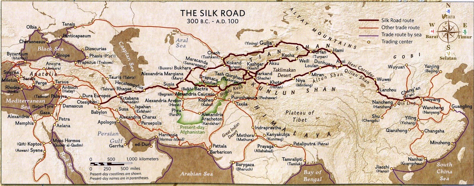 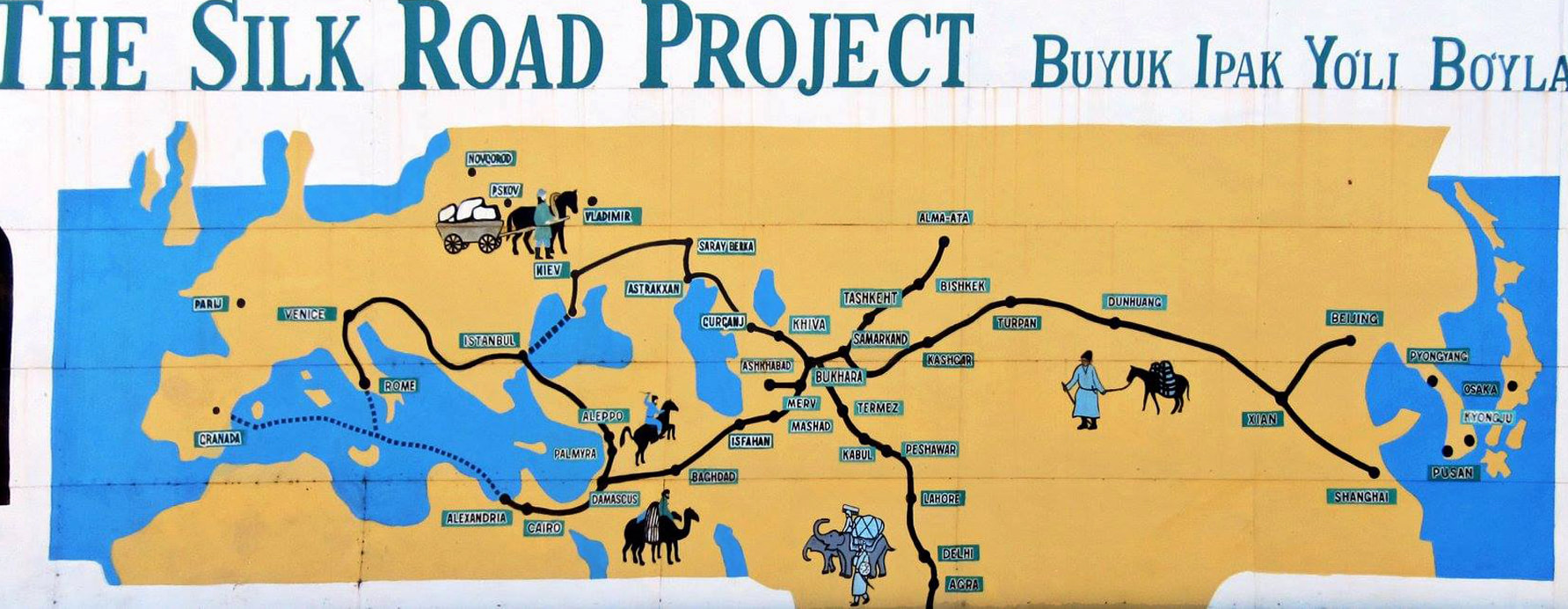 China New Silk Road Project The Silk Road Economic Belt that would run across the Eurasian landmass may provide alternatives that offset some of China’s vulnerabilities along major sea lanes. China would carve out a continental sphere of influence from which it could compete against the United States and other seapowers. Railways, roads, and pipelines, along with PLA bases and logistics facili-ties for landward purposes, would provide secure access to markets across Eurasia. It may be a kind of insurance policy to hedge against resistance, instability, or war at sea. But it is unlikely to supplant the Maritime Silk Road as the dominant mode for China’s future development. This study thus assesses that China cannot profitably go global via a continental strategy without incurring heavy costs or without compromising its returns on investment overseas. Kenyan government risks losing the lucrative Mombasa port to China should the country fail to repay huge loans advanced by Chinese lenders. It is a strategic foothold along a critical commercial and military waterway. Built at a cost of US$3,6 billion and connecting the Indian Ocean city of Mombasa with Nairobi's capital, SGR is the most expensive infrastructure project since Kenya's independence in 1963. China Exim Bank would become a principle in KPA if Kenya Railways Corporation (KRC) defaults in its obligations. The Inland Container Depot in Nairobi is also at stake, which receives and dispatches freight hauled on the new cargo trains from the seaport. A takeover would also mean thousands of port workers who would be forced to work under the Chinese lenders. Kenya public debt is estimated to be over $49,65 billion, which is more than 56% of its GDP. In 2018, Zambia lost the Kenneth Kaunda International Airport to China over debt repayment. Many nations including Djibouti, Tonga, the Maldives, the Republic of Congo, Kyrgyzstan, Cambodia, Niger, Laos, Zambia, Samoa, Vanuatu, and Mongolia now have debts to China at more than 20% of their GDP. As a result, many of these nations have had to hand over ownership of several investments, and swathes of sovereign territory to the Chinese government. Djibouti, heavily indebted to China, offered Beijing a military base, China's first outside its borders. “Only A Drunkard Would Accept These Terms”, Tanzania President rejected China’s killer loans & has initiated a renegotiation process by pressing the investors to bring down the lease period to 33 years from 99 years. In 2018, unable to afford the repayments, Sri Lanka handed control of the Hambantota port to a subsidiary of China Communications Construction Company (CCCC) for at least 99 years, described as “the biggest game changer in 100 years”. This transfer was part of a debt swap totalling USD 1.2 billion.  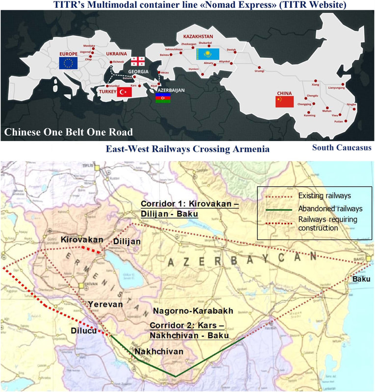 Rail is fast but expensive, and no one would do that except as a propaganda ploy or in the absence of huge subsidies.
0 Comments
|
